News
NASA’s MISR Instrument Sees California Wildfire Smoke Plumes From Space
Wednesday, August 25th 2021 04:45 PM
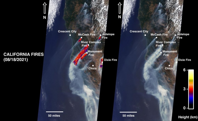
NASA's MISR instrument captured smoke plumes from five fires burning in northern California. The highest plume reached about 19,685 feet (6,000 meters) in altitude. Credit: NASA/GSFC/LaRC/JPL-Caltech, MISR Team Full Image Details
Smoke from several large wildfires burning in Northern California can be seen traveling miles into the atmosphere.
As of Aug. 24, wildfires in Northern California – including the McCash, Antelope, River Complex, Monument, and Dixie fires – have scorched more than 1 million acres of land. The Dixie Fire, the state’s second largest in history, accounts for 731,310 acres. On Aug. 18, NASA’s Multi-angle Imaging SpectroRadiometer (MISR) instrument, aboard the Terra satellite, acquired new data showing smoke from these fires.
The MISR instrument has nine cameras that view Earth at different angles. The right side of the image shows smoke from the five fires as observed by MISR’s nadir (downward-pointing) camera. The multi-ang...
Read More
Read More
Comet Atlas May Have Been a Blast From the Past
Friday, August 20th 2021 04:37 PM
It's suspected that about 5,000 years ago a comet swept within 23 million miles of the Sun, closer than the innermost planet Mercury. The comet might have been a spectacular sight to civilizations across Eurasia and North Africa at the end of the Stone Age.
This pair of Hubble Space Telescope images of comet C/2019 Y4 (ATLAS), taken on April 20 and April 23, 2020, reveal the breakup of the solid nucleus of the comet. Hubble photos identify as many as 30 separate fragments. The comet was approximately 91 million miles from Earth when the images were taken. The comet may be a broken off piece of a larger comet that swung by the Sun 5,000 years ago. The comet has been artificially colored in this view to enhance details for analysis.
However, this nameless space visitor is not recorded in any known historical account. So how do astronomers know that there was such an interplanetary intruder?
Enter comet ATLAS (C/2019 Y4), which first appeared near the beginning of 2020.
Comet...
Read More
Read More
James Webb Space Telescope expected to launch in 2021
Thursday, August 19th 2021 04:27 PM
NASA’s James Webb Space Telescope is a true technological marvel. The largest and most complex space telescope ever built, Webb will be able to gather light that has been traveling for 13.5 billion years, almost since the beginning of the universe. In effect, Webb is a time machine, allowing us to peer at the first galaxies to form after the Big Bang. Because it gathers infrared light, it will see right through the giant clouds of dust that block the view of most other telescopes. Webb will be 100 times more powerful than the Hubble Space Telescope. Most notably, once it unfolds its 21-foot-wide (6.5-meter-wide) set of segmented mirrors, Webb will be powerful enough to search for water vapor in the atmospheres of planets orbiting other stars. It will open a new window on these exoplanets, observing them in wavelengths of light at which they have never been seen before and helping us gain new insights about their nature. Webb will help us understand how galaxies evolve over bill...
Read More
Read More
Astronomers Find a ‘Break’ in One of the Milky Way’s Spiral Arms
Wednesday, August 18th 2021 04:11 PM
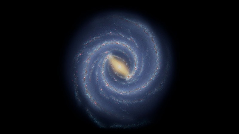
This illustration shows astronomers’ current understanding of the large-scale structure of the Milky Way. Stars and star-forming regions are largely grouped into spiral arms. Measuring the shape, size, and number of spiral arms is a challenge because Earth is locate inside the galaxy. Credit: NASA/JPL-Caltech
A contingent of stars and star-forming clouds was found jutting out from the Milky Way's Sagittarius Arm. The inset shows the size of the structure and distance from the Sun.
The newly discovered feature offers insight into the large-scale structure of our galaxy, which is difficult to study from Earth’s position inside it.
Scientists have spotted a previously unrecognized feature of our Milky Way galaxy: A contingent of young stars and star-forming gas clouds is sticking out of one of the Milky Way’s spiral arms like a splinter poking out from a plank of wood. Stretching some 3,000 light-years, this is the first major structure identified with an ori...
Read More
Read More
Fizzing Sodium Could Explain Asteroid Phaethon’s Cometlike Activity
Tuesday, August 17th 2021 04:16 PM
This illustration depicts asteroid Phaethon being heated by the Sun. The asteroid’s surface gets so hot that sodium inside Phaethon’s rock may vaporize and vent into space, causing it to brighten like a comet and dislodge small pieces of rocky debris. Credit: NASA/JPL-Caltech/IPAC
Models and lab tests suggest the asteroid could be venting sodium vapor as it orbits close to the Sun, explaining its increase in brightness.
As a comet zooms through the inner solar system, the Sun heats it, causing ices below the surface to vaporize into space. The venting vapor dislodges dust and rock, and the gas creates a bright tail that can extend millions of miles from the nucleus like an ethereal veil.
Whereas comets contain lots of different ices, asteroids are mainly rock and not known for producing such majestic displays. But a new study examines how near-Earth asteroid Phaethon may in fact exhibit cometlike activity, despite lacking significant quantities of ice.
Known to...
Read More
Read More
NASA Announces Date for SpaceX’s 23rd Cargo Resupply Mission
Monday, August 16th 2021 08:50 PM
The SpaceX Falcon 9 rocket with the Dragon capsule atop is raised to the vertical position on June 2, 2021, at Launch Complex 39A at NASA’s Kennedy Space Center in Florida, in preparation for the company’s 22nd Commercial Resupply Services mission for NASA to the International Space Station. NASA and SpaceX are targeting Saturday, Aug. 28, at 3:37 a.m. EDT, for launch of the 23rd commercial resupply services mission.
NASA commercial cargo provider SpaceX is targeting Saturday, Aug. 28, to launch its 23rd commercial resupply services mission to the International Space Station. SpaceX’s Falcon 9 rocket carrying the company’s Dragon spacecraft is scheduled for liftoff at 3:37 a.m. EDT from Launch Complex 39A at NASA’s Kennedy Space Center in Florida.
The spacecraft will deliver a variety of NASA science investigations, including a study on preventing and treating bone density loss, an investigation that will test diagnostic devices that could detect...
Read More
Read More
DART Gets Its Wings: Spacecraft Integrated with Innovative Solar Array Technology and Camera
Friday, August 13th 2021 04:13 PM
Perched atop a stand in the middle of a high-ceilinged clean room, DART is beginning to look like the intrepid spacecraft that will aim itself directly into an asteroid next fall. With the addition of its compact Roll-Out Solar Arrays (ROSA) coiled into two gold cylinders that flank the sides of the spacecraft, and its less visible but still integral imager, the Didymos Reconnaissance and Asteroid Camera for Optical (DRACO) navigation tucked safely beneath its panels, the spacecraft is close to fully integrated.
This mix of current and new technologies, some of which it will demonstrate for the first time, will see DART through its 10-month journey toward its asteroid target.
The recently installed Roll-Out Solar Arrays (ROSA) and Didymos Reconnaissance and Asteroid Camera for Optical (DRACO) navigation are two critical technologies that will enable the DART spacecraft to navigate through space and effectively reach the Didymos asteroid system.
NASA's DART, the Double Ast...
Read More
Read More
NASA Spacecraft Provides Insight into Asteroid Bennu’s Future Orbit
Thursday, August 12th 2021 04:30 PM
This mosaic of Bennu was created using observations made by NASA’s OSIRIS-REx spacecraft that was in close proximity to the asteroid for over two years. Credit: NASA/Goddard/University of Arizona
Along with collecting a sample from the Bennu’s surface, the spacecraft provided precision data to better predict the near-Earth object’s orbit around the Sun.
In a study released Wednesday, NASA researchers used precision-tracking data from the agency’s Origins, Spectral Interpretation, Resource Identification, Security-Regolith Explorer (OSIRIS-REx) spacecraft to better understand movements of the potentially hazardous asteroid Bennu through the year 2300, significantly reducing uncertainties related to its future orbit, and improving scientists’ ability to determine the total impact probability and predict orbits of other asteroids.
The study, titled “Ephemeris and hazard assessment for near-Earth asteroid (101955) Bennu based on OSIRIS-REx dat...
Read More
Read More
How many Perseids will I see in 2021?
Wednesday, August 11th 2021 04:36 PM
Many Perseid-related news stories and social media posts state that the maximum rate is about 100 meteors per hour, which is a lot. So, folks get excited and go out on the peak night, braving mosquitos and other nightly hazards. But they are often disappointed; we routinely hear, “I went out and only saw a few meteors. Not even 20, much less 100!” And they would be right. The problem is that the 100 per hour is a theoretical number used by meteor scientists and does not convey what people are actually going to see.
In the 1980’s, meteor researchers were searching for a way to compare the meteor shower rates observed by various individuals and groups across the globe. People were reporting the rates, but the differences in sky conditions, radiant altitude and observer eyesight made getting a comprehensive view of shower activity difficult.
So, the meteor researchers put their heads together and came up with the concept of a ZHR, or Zenithal Hourly Rate. The ZHR is...
Read More
Read More
NASA’s TESS Tunes into an All-sky ‘Symphony’ of Red Giant Stars
Monday, August 9th 2021 08:58 PM
Using observations from NASA’s Transiting Exoplanet Survey Satellite (TESS), astronomers have identified an unprecedented collection of pulsating red giant stars all across the sky. These stars, whose rhythms arise from internal sound waves, provide the opening chords of a symphonic exploration of our galactic neighborhood.
TESS primarily hunts for worlds beyond our solar system, also known as exoplanets. But its sensitive measurements of stellar brightness make TESS ideal for studying stellar oscillations, an area of research called asteroseismology.
“Our initial result, using stellar measurements across TESS’s first two years, shows that we can determine the masses and sizes of these oscillating giants with precision that will only improve as TESS goes on,” said Marc Hon, a NASA Hubble Fellow at the University of Hawaii in Honolulu. “What’s really unparalleled here is that TESS’s broad coverage allows us to make these measurements uniform...
Read More
Read More


